By
Spider Rybaak
Spawned by the completion of the
Lighthouse Hill dam in 1930, the Lower Salmon River Reservoir in the town of
Orwell covers 164 acres. Dropping to a maximum depth of 50 feet, and averaging
half that, the place offers good fishing for warm water and cold water species.
Rick Smith, a local guide (315-532-5937) who knows the reservoir intimately, says large mouth bass are the most popular game fish.
Most range from 12 to 18 inches; and 20-something inchers are taken regularly.
Five-pounders are caught each year and 6-pounders have been reported.
Hanging out along the reservoir’s edge,
they hit all the usual suspects. Locals are particularly fond of catching them on
surface lures, especially fly-rod-sized poppers worked along the shoreline.
“Small mouths are also available,”
says Smith. "There aren’t as many as there are large mouths, but they
average two pounds, always seem to be hungry and fight every bit as hard.”
Rainbow trout fry are stocked
regularly; 4,300 last spring. Most end up as snacks for bigger trout and bass but
enough survive to make the place a local hot spot for “bows” ranging from 8 to
12 inches.
The trout are easily accessible,
too. The CR 22 Bridge at Bennett's Bridges is only a little over 100 yards
downstream of the powerhouse discharge. And although you can’t fish from the
bank below the power plant, "you can cast real close to it from the
bridge.”
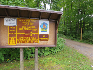
On the other side of the road, the Salmon River Project Bennett Bridges Day Use Site offers
a beach launch (no motors allowed), parking for about 20 rigs, easy access to
the mouth of the Salmon River and several hundred yards of bank fishing.
Finally, the reservoir is loaded with pan fish. Smith claims
“There’s a lot of yellow perch in the 8 to 10-inch range, fat rock bass
averaging a solid 8 inches and slab crappies.”


